Zooniverse – Sudan Road Access Project
I’m an active participant in the Zooniverse community and regularly receive newsletters regarding new projects. In the past I’ve been involved with Star Notes – helped to transcribe the groundbreaking work of early Harvard astronomers, Galaxy Zoo – helped classify how galaxies formed according to their shapes, WWII Army Separation Notices – helped to categorize Separation Notices in order to create accurate and searchable digital records, Nest Quest Go: Wrens – transcribed nest records to discover the behavioral patterns, and Solar Jet Hunter – helped to classify solar jets.
You too can join Zooniverse and assist in any of the hundreds of projects. Anything from the arts to biology, history, language, medicine, space and more. A little something for everyone from A to Z. So, become an active volunteer and help make the world a better place through your research.
Today, there is an urgent call for support for the Sudan Road Access Project
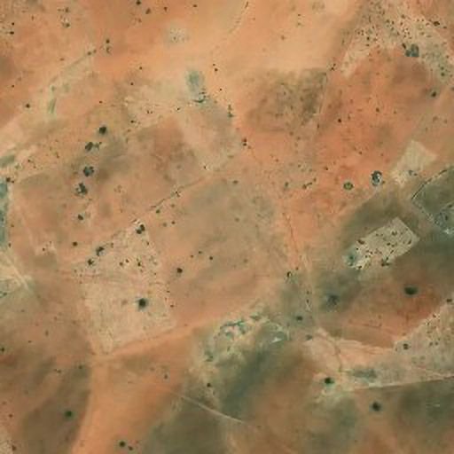
Due to the sensitivity around the conflict in Sudan, there is an increasingly urgent demand for the data from the Logistics Cluster: Sudan Road Access Project. Because of this we are pushing to complete the project by July 2025, the start of the rainy season in Sudan. We are marking where wadis – dry riverbeds – cross over roads. This data helps the Logistics Cluster to plan effective and efficient humanitarian access routes in Sudan, as rainy season flooding massively affects road access.
Since starting the project, we have split the data up into 19 geographical areas. To date, we have completed the Central and West Darfur regions and Khartoum. Currently, the South and East Darfur regions are active on the project and need classifying. We will ensure to add the next areas, as we complete these regions.
We have been analysing the data we have already, and it looks very accurate, we are so impressed by it. Take a look at our project Results page for up to date examples of the classified data, we think it is fantastic! For this reason, we want to push this project to completion as it will be a very valuable dataset for the humanitarian community working in Sudan. The Logistics Cluster are eager to import the data into their LogIE platform. We have been assured that this data is extremely valuable to the humanitarian community and will be used directly within the logistical humanitarian aid decision making process.
Sudan is geographically large; we need a big push to complete the dataset to this deadline. Please help us by classifying some of the data! Briefly, we are marking how much of a road is affected by a wadi (dried riverbed), to understand which roads maybe at risk to flooding during the rainy season. This information will be used for humanitarian aid planning, to organize the most effective routes for aid convoys to take.
Please let us know if you have any questions or comments in the project Talk page, we are welcome to hearing suggestions and happy to answer questions!
If you are in distress and need or want support, here is a list of international crises support hotlines so you can get support wherever you are in the world.
Please visit the Sudan Road Access Project at https://www.zooniverse.org/projects/alicemead/sudan-road-access-logistics-cluster
Leave a Reply
You must be logged in to post a comment.