
Helicopters documenting groundwater in Michigan
Low-attitude helicopter flights documenting groundwater in Michigan counties
If you notice helicopters flying overhead with a strange apparatus hanging from a cable, don’t freak out. It’s not nefarious. It’s not spying on you. It’s looking at water tables.
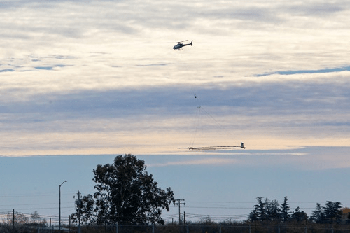
Local officials and residents in numerous Michigan counties may notice low-flying helicopters carrying a suspended apparatus in the coming months. In partnership with the Michigan Department of Environment, Great Lakes, and Energy (EGLE), the U.S. Geological Survey (USGS) is conducting an Airborne Electromagnetic (AEM) Survey project in southwest Michigan this spring to improve available data on Michigan’s groundwater availability and aquifer mapping. The study entails helicopters flying at about 200 feet with a suspended hoop-like horizontal frame on a cable about 100 feet below the aircraft that measures differences in Earth’s electrical properties and magnetic field created by different rock types across the survey area. The technology does not collect photos or videos.
The flights, completed during the day only, are flown by specially trained pilots and will not pass over buildings at low altitude. The flights will avoid densely populated areas and pose no risk to humans, animals or plant life. The survey will cover Allegan, Barry, Berrien, Branch, Calhoun, Cass, Eaton, Hillsdale, Ingham, Ionia, Jackson, Kalamazoo, Kent, Ottawa, St. Joseph and Van Buren Counties. Exact dates of flights are weather dependent, and the USGS will update a flight tracker on the study website with daily progress.
What is Airborne Electromagnetics?
First applied in the 1950’s, airborne electromagnetics (AEM) is a geophysical technology that is used to
map groundwater resources throughout the world. It measures variations in the electrical conductivity of
the ground. Electrical conductivity of rocks and soils is a property that depends on composition and water
content. AEM detects geological changes and moisture variations beneath the earth’s surface.
How does it work?
Electrical conductivity is measured using a helicopter carrying a suspended large wire loop that houses a
sensor and instrument package. The sensor is flown about 100 feet (35 m) above the ground surface.
The system transmits weak low-frequency radio waves into the ground to more than 1000 feet (300 m)
deep and measures the response that returns from the ground. The surveys are conducted along pre-
planned flight paths that follow a “lawn mowing” pattern in order to cover an area as completely as
possible.
Is airborne electromagnetics a safe technology?
AEM is safely used throughout the world for a variety of geologic studies and in the evaluation of land
features and natural resources. The electromagnetic signals generated by this system are considerably
weaker than the signals generated by natural and man-made sources (for example, lightning and
broadcast radio stations) surrounding us every day. All operations must pass strict government aviation
regulations, and the aircraft are flown by specialists who have many decades of experience collecting
data in a wide variety of flying environments. The helicopter stays high enough that there is no rotor wash
(wind) felt on the ground. It also keeps well above power lines and other obstacles. The survey sensor is
securely fastened with a stainless-steel wire rope and a backup Kevlar safety rope. In accordance with
FAA safety regulations, the flight paths do not cross over buildings.
Does EM affect wildlife?
The technology causes no ill effects to wildlife, but because low-flying helicopters are involved, there is
the potential for animals to be alarmed and briefly disturbed.
Does EM affect electronics or communications equipment?
No, the electromagnetic field generated by the equipment is far too weak to interfere with electronic or
communications equipment.